Category Archives: Weather With a Name

Ian Recalibrates, Aims for Tallahassee

Promoted to Ian from TD9, the soon-to-be category 3 (at least) storm has a new projected track. The current projection, still much subject to change,is significantly westward of Friday’s, now avoiding south Florida entirely, before making a now more-leisurely turn to the East, weakening a bit, and heading straight for Tallahassee.

If Ian does hit Tallahassee, don’t hold your breath for claims from local divines that Ian is divine retribution for the recent actions of Gov. Evil™ and the state legislature.


Posted in Florida, Weather With a Name | Comments Off on Ian Recalibrates, Aims for Tallahassee

TD 9 09/22/2022

It’s a cliched scene in old war movies: Sentries are looking out at the world from their fort or embankment, and saying, “It’s quiet out there. Too quiet.”

Well, that’s what it felt like to South Florida this year as we looked at the weather maps. After meteorologists predicted a bumper crop of named hurricanes this year, what storms there have been acted as if Miami were dosed in super-hurricane repellent, with every storm that even looked as it it might come here, aiming elsewhere from an early stage–and staying that course.

Seems now that the quiet might be over.

TD 9 Track as of 9/22/2022

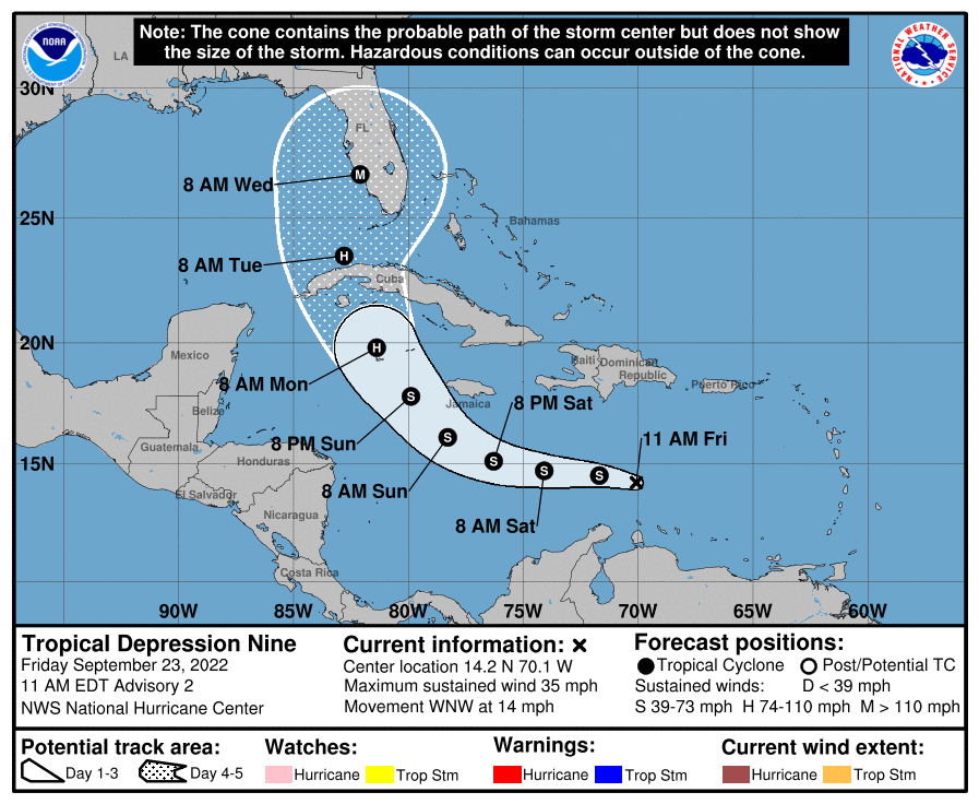
While a five-day track is very often subject to major change, that just means that it can aim more directly at us, as well as go further away.

And the key detail is that little tiny “M” on the track for Wednesday. “M” stands for “major”. Could be a very big one…or nothing for us if it goes to sea and heads for the gulf coast. [Update: the prediction is for Class 3, which ranges from bad to quite bad, but commonly doesn’t rate as utterly disastrous to life in places where buildings are designed to survive it.]

Note: No sharpies were used in the creation of this post.

Posted in Weather With a Name | Comments Off on TD 9 09/22/2022

Not Panicking Yet (Tropical Storm Isaias)

Miami is hardened for wind. Most tropical storms just beat up vegetation and some power lines. You don’t want to be out walking or driving in it, and it makes some noise, but in most cases things are mostly OK the next morning. It’s when it gets to hurricane-force winds that I start to worry.

And hurricane force winds are a possibility here, although not it seems a strong possibility.

National Weather Service says:

By late Friday, a mid-latitude trough moving into the east-central United States is expected to weaken the western portion of the ridge. This pattern should cause the cyclone to turn northwestward to north-northwestward on Saturday when it is near the northwestern Bahamas and South Florida. As the trough slides eastward over the United States, this should steer Isaias northward and northeastward early next week. Although the bulk of the track guidance agrees on this overall scenario, the confidence in the track forecast remains lower than usual due to the expected land interaction and possible center reformation in the short term. The new NHC track forecast is a blend of the HFIP corrected consensus and the TCVA multi-model consensus, and is similar to the previous advisory.

The intensity forecast remains challenging. The structure of the storm is likely to be disrupted by its passage near or over Hispaniola today, and some weakening is likely. Once the system moves away from the Greater Antilles gradual strengthening is anticipated. The global models and the SHIPS guidance suggest that Isaias will encounter an area of moderate southwesterly shear over the weekend, and the NHC intensity forecast is again leveled off at that time. There are models that continue to suggest Isaias could become a hurricane when it is near the U.S., but given the continued uncertainty, the NHC intensity forecast remains near the intensity consensus.

Also, the track has moved East some in the past day or two; that could continue too….

Of course, there’s a lot of food in the freezer right now, so it would be a lousy time to lose power.

Posted in Weather With a Name | Comments Off on Not Panicking Yet (Tropical Storm Isaias)

Watch Out for Hurricane Sheldon

AOC teams up with the Intercept, Naomi Klein, and illustrator Molly Crabapple to imagine a happy future in which the Green New Deal helps save the planet.  Well, most of the planet.  Pity about Miami.  (See video at 6:02.)

Posted in 99%, Weather With a Name | Comments Off on Watch Out for Hurricane Sheldon

I Hate Reruns

I almost never watch a movie twice (except of course Groundhog Day).

I generally hate re-runs.

And so far this Maria show looks like an Irma rerun:

Posted in Weather With a Name | 1 Comment

Coral Gables / FPL Update

It seems FPL cleaned up the downed power lines yesterday, but has revised its estimate to turn on all the power in the area to Tuesday.  We’ll see if Coral Gables goes through with its threat to impose fines.

I was out for a brief drive to the library today (Comcast still hasn’t fixed the internet, and the library has wifi) and saw a lot of electricity trucks working in the area. Hard to know, but maybe that letter from the Commission had an effect; or maybe it’s just our turn.

Posted in Coral Gables, Weather With a Name | 2 Comments