
Category Archives: Miami

Good News, Bad News

Good News (for us): We've been downgraded to a mere Tropical Storm Watch. Frances the Slow is now on land, terrorizing other people — don't know about casualties, but there seems to be significant property damage and a lot of people are without power.

Bad News (for us): Ivan is now a Hurricane and he's headed straight for us.
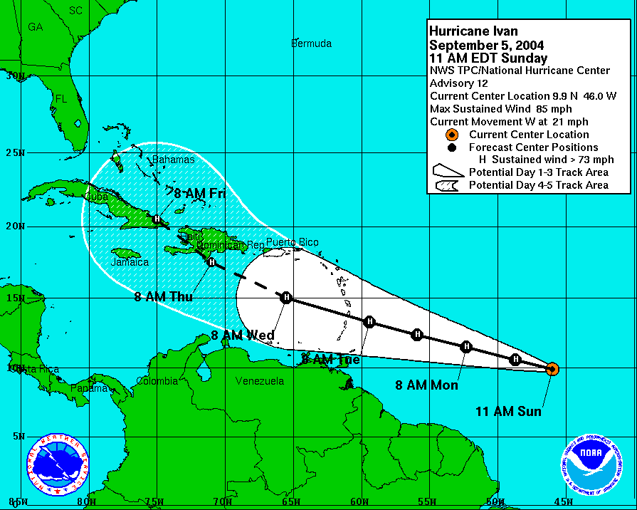
National Hurricane Center IVAN IS STRENGTHENING RATHER RAPIDLY AT THIS TIME. THE EYE IS BECOMING BETTER DEFINED ON THE VISIBLE IMAGERY AND DVORAK INTENSITY ESTIMATES SUPPORT AT LEAST 75 KT FOR THE CURRENT INTENSITY. THIS MAKES IVAN THE STRONGEST TROPICAL CYCLONE FOR SUCH A LOW LATITUDE IN THE ATLANTIC BASIN RECORDS. CIRRUS OUTFLOW IS WELL ESTABLISHED OVER ALL QUADRANTS OF THE HURRICANE. ALL PARAMETERS SEEM TO BE IN PLACE FOR IVAN TO CONTINUE STRENGTHENING…AND THERE IS A HIGH LIKELIHOOD THAT THIS WILL BECOME THE SEASON'S FOURTH MAJOR HURRICANE. THE OFFICIAL WIND SPEED FORECAST IS SIMILAR TO THE SHIPS GUIDANCE…AND IT MAY BE CONSERVATIVE.
Posted in Miami | 2 Comments

Windy

Frances is north east of here and heading somewhat northwesterly, so unless it does an Andrew and skitters south as it hits land, we're going to be subject to tropical storm winds at the worst, plus some gusts, and maybe not even that. But it's so slow now that it may take another 16-24 hours, or even more, before we know it's safe to take down the shutters.

So far, it's pretty windy, and there's been some rain, but nothing you would get excited about if they didn't have those big swirly cloud pictures at the National Center for Atmospheric Research.

The Miami Herald delivered a special early edition last night since they figured they might not be able to get through the water this morning; that was before Frances slowed down ever farther (more waiting in the dark behind our shutters!). The NYT didn't deliver at all. The electricty has the occasional flicker, but so far so good.

Our next problem is that Tropical Storm Ivan. Frances needs to get out of the way so that they can open the shops — I don't think we have enough food for two storms in a row.

Posted in Miami | Comments Off on Windy

The Calm Before the Storm or Non-Storm

The weather is here, and it’s nice right now. A friend has two kids over who have been evacuated from Miami Beach, and they are about the age of our kids, so we took our kids swimming in their pool to keep the them company. We were driven inside by a squall after about 30 minutes, a feeder band passing over we later learned, but that passed quickly and the weather turned nice, if sometimes blustery after that.

This morning I went out first thing to buy more extension cords, since in the course of the construction on our house some of the old ones went walkabout. Streets were nearly empty, but the hardware store, while heavily picked over, was not empty. They still had some batteries, for example; I left them there, since we have many and a generator, but not without a pang, remembering Andrew and those five weeks without electricity — two weeks plus without a candle or a flashlight or a clue (we had literally just moved here from London).

As for Frances, the possibility of anti-climax grows with each hour. I can only hope.

Posted in Miami | 2 Comments

OK. This Is Serious

UM-FSU football game rescheduled for 8 p.m. Sept. 10.

Posted in Miami | Comments Off on OK. This Is Serious

Frances: Forecasters Cannot Agree

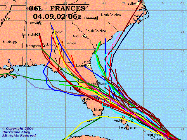
The National Weather Service and the news give us the consensus track, and a large bubble of uncertainty around it. That forecast, though, is built out of many different models. Often those models mostly agree. Not this time:

hurricane.gif

Source: Boat U.S. Hurricane Center.

Posted in Miami | Comments Off on Frances: Forecasters Cannot Agree

11pm Frances Report

We have a hurricane watch along with much of the bottom half of the Florida coast.

Offical odds for a hit on Miami remain almost unchanged, with the bulls-eye still just enough north of here to make the misery go elsewhere. Our cumulative chance of a strike has risen to 20%, but that's only because the new tables project further out into Saturday. The peak period remans 11% between 8PM Thursday and 8AM Friday. Meanwhile, however, the National Weather Service's discussion of the track, which has been dominated for two days by puzzlement as to why the various different models diverge so much, has taken on a new note.

I don't know why the National Hurricane Center forecasters still have to WRITE THEIR ANALYSIS IN ALL CAPS just like they probably did in the days of the telegraph, but here is the 11pm discussion of the meteorology? I have taken the liberty of adding bold to the parts that caught my eye:

RECON THIS AFTERNOON AND EVENING INDCIATED THE CENTRAL PRESSURE HAD DECREASED TO 939 MB. A DROPSONDE AT 01/1904Z INDICATED WINDS OF 154 KT…OR 177 MPH…AT THE 850 MB LEVEL. THE HIGHEST 700 MB RECON FLIGHT-LEVEL WIND AT 2210Z WAS 134 KT…EQUAL TO ABOUT A 121-KT SURFACE WIND. BASED ON THIS INFORMATION…FRANCES IS BEING HELD AT 120 KT…WHICH MAY BE A LITTLE CONSERVATIVE.

THE INITIAL MOTION IS 295/12. HOWEVER…THERE HAS BEEN CONSIDERBALE WOBBLE IN THE TRACK THE PAST 12 HOURS DUE TO THE EYEWALL REPLACEMENT CYCLES THAT HAVE BEEN OCCURRING. FRANCES HAS BEEN MOVING WEST-NORTHWESTWARD FOR THE PAST 24 HOURS UNDER THE INFLUENCE OF THE SUBTROPICAL RIDGE TO THE NORTH…WHICH IS EXPECTED TO REMAIN INTACT THROUGH AT LEAST 48 HOURS. THE GULFSTREAM-IV JET AND AN AFRES C-130 HAVE BEEN RELEASING DROPSONDES AROUND THE PERIPHERY OF FRANCES. THE SONDE DATA HAS PRODUCED SOME INTERESTING AND DISTURBING RESULTS. THE HEIGHT DATA FOR THE VARIOUS PRESSURE LEVELS…COMPARED TO 18Z SURROUNDING UPPER-AIR DATA…APPEAR TO BE AT LEAST 20 METERS TOO LOW. HOWEVER…THE WIND DATA CLEARLY INDICATE A MID-TROPOSPHERIC HIGH PRESSURE CENTER NEAR 30N 75W…OR ABOUT 500 NMI NORTHWEST OF FRANCES WITH A RIDGE AXIS EXTENDING WEST-SOUTHWESTWARD ACROSS NORTH FLORIDA AND INTO THE NORTHEAST GULF OF MEXICO. IN THE SHORT TERM… THIS WOULD SUGGEST THAT FRANCES SHOULD CONTINUE MOVING AT 295 OR EVEN 290 DEGREES MOTION FOR THE NEXT 24 HOURS OR SO. ALSO…00Z UPPER-AIR DATA INDICATE THAT THE 18Z NOGAPS AND 12Z UKMET MODELS HAVE VERIFIED THE 00Z 500 MB RIDGE AND HEIGHTS THE BEST…WHILE THE 18Z GFS AND GFDL MODELS WERE MUCH TOO WEAK…AT LEAST 20 METERS TOO LOW…WITH THE STRENGTH OF THE RIDGE. SINCE THE 00Z MODEL RUNS WILL HAVE THE NEW GPS DROPSONDE DATA INCLUDED IN THOSE RUNS FOR THE 06Z ADVISORY…NO SIGNIFICANT CHANGE IS BEING MADE TO THE PREVIOUS FORECAST TRACK. HOWEVER…WITH HIGH PRESSURE LOCATED TO THE NORTHWEST OF FRANCES…I WOULD NOT BE SURPRISED TO THE 00Z MODEL TRACKS SHIFT A LITTLE MORE WESTWARD.

That would be…this way.

Posted in Miami | 2 Comments